Background information | Contact details

Calais Citadelle & Forts:
English and French town defences


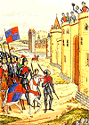
Edward III's army arrives at the gates of Calais with a besieging army - 1346.

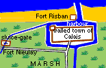
After capturing Calais, the English used natural features to turn it into an "impregnable stronghold": 1347 - 1558

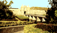
Medieval walled town
The fishing village of Calais became a port under the protection of the Count of Boulogne in the 12th century. He built a castle and town walls. These were so strong that they held out against an English siege for 11 months in 1346. See - '
story of six burghers'.
Back to top

The Six Burghers 1347

After a year of siege, the inhabitants trapped inside Calais were starving. Normally people in a besieged town who fought back would expect to be killed if the attackers succeeded. Six leading citizens offered their own lives if Edward III spared the rest of the townsfolk.

His queen took pity on them, and asked if the brave burghers could also be spared if the town surrendered. Edward III agreed. The citizens of Calais lost their homes and property, but were permitted to leave without further bloodshed. Back to top

English stronghold (1347-1558)
When the English took over the walled town from the unfortunate French inhabitants, they strengthened the walls and towers to take more cannons. They added a strong tower, Fort Risban, to protect the key harbour entrance - their supply line to England.

Border castles held the edges of the English occupied area (the "Pale") at Sangatte, Coquelles, Frethun, Hames, Guînes, Balinghem and Marck.
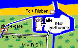
Back to top


OLD MAP [left] of the walled town of Calais, showing the tidal harbour and its narrow outlet to the sea through the sand dunes, guarded by the small Fort Risban.
FORT NIEULAY
[bottom left and above] - photo shows ruined chapel and the channel (now dry) by which the marshes round Calais would be flooded by the high tide

MAP: fortifications and waterways round Calais

Flooding the marshes
In the Middle Ages Calais was surrounded by vast areas of marshland. Much of this had been drained and used for pasture. To the west of Calais was a point where all the ditches drained into the sea. This was also the only passable road into the town - roughly along the route of the N1.

English and Flemish engineers built a fort - Fort Nieulay- to control this key point, with sluice-gates that could be opened to the sea. At high tide, seawater would flood all the low-lying land round Calais. In the event of an attack, this would make it very difficult for an enemy to bring siege weapons near the town walls. Back to top

French re-capture 1558
Calais was regarded as invincible, but in 1557 French spies carefully surveyed the defences and saw they were under-manned and in poor repair. Next year, they surprised the defenders of Fort Nieulay on New Year's Eve (by English custom, they were drunk! ...and sieges were not expected in mid-winter). It fell in a day, without the vital sluices being opened. Next day, Fort Risban fell, and after four days, the English governor surrendered the town. Guînes castle still held out - but while the English dithered (could they could afford to send an army? should they accept a Spanish offer to counterattack from the Spanish Netherlands?) the French captured that, too. English humiliation was complete.
Back to top


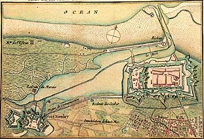
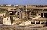
Above: French engineers demolished the medieval castle, and built a Citadelle at the western end of the town.
Right: Errard cut a moat across the western end of the walled town, and created a citadelle strongpoint. The town walls and two outer forts were modernised, with heavy angular earthworks.

Frontier fort
Calais was now France's frontier fort, not far from Gravelines, then the border stronghold of the Spanish Netherlands. At the beginning of the 17th century, French king Henri IV employed Jean Errard (1554-1610), the "father of French fortification", to build citadels here at Calais and Ardres - following Italian ideas.

16th century changes after French re-capture in 1558


Back to top

Vauban
Later 17th century, king Louis XIV successfully pushed France's border further east. He set Royal military engineer Vauban to build a chain of fortifications to secure the new borders of northern France. They spent more money developing forts and the port at Dunkerque (which later had to be given up), but Vauban also further modernised the Calais' ramparts and Citadelle to form the coastal end of a second “back-up” line of defences.
Back to top

Today
Calais' fortifications were heavily altered by German occupation in WW2. At Fort Nieulay, the unique fort and sluice have been restored and stand at the centre of a park. The Citadelle is now used as a sports centre. Fort Risban is a campsite at the harbour mouth. All can be visited.
Back to top

...Send in a review..
Reviewer - ??
Location:
Information/ reservations:
Office de Tourisme, 12 boulevard Clémenceau, 62100 CALAIS
Tel: 00 33 3 21 96 62 40 - Fax: 00 33 3 21 96 01 92

Background Information

Vauban - 17th century military engineer
England's relations with France
Hundred years' War
History of Flanders

Home

Map

A-Z
Calais

Calais lace

www.theotherside.co.uk © Copyright 1999-2000 Invicta Media. Last updated 16th May 2002/ 26th September 2000