|
|
|
|
How the Channel was formed |

|
Was England
once joined to France? |
 |
STRANGE
FACTS! |
|
|
||
|
|
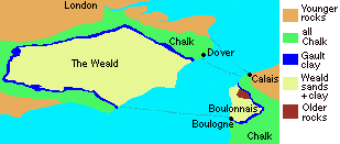
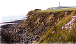
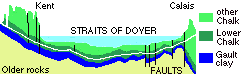
In the 18th century, the first amateur geologists began mapping the rocks either side of the Channel . The chalk cliffs and other similarities suggested that - perhaps - England might once have been joined to France. But what made the 22 mile (30km) gap between Dover and
Calais? |
|
Fault-lines
along the Channel |
|
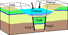 Fault lines cause occasional earthquakes |
Geologists call this a "rift valley". Earthquakes There was a major earthquake in 1580, and again in 1995 (4.9 on the Richter scale). This lower land is more likely to be eroded by rivers and
the sea - and that's what happened in the last Ice
Age... |
|
Changing
sea-levels and the last Ice
Age Winter snows in the far north did not melt in the summer, so huge ice sheets started to pile up. |
|
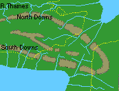
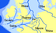 MAP 1: 25,000 years: When sea-level were much lower , the rivers flowed across grassy plains where the sea used to be. |
Ice sheets blocked the
North Sea Ice sheets 1,500 metres thick covered northern Britain and much of the Continent. Sea levels fell considerably because so much water was
trapped in the growing ice sheets - Map
1 shows that rivers of Nord - Pas de Calais flowed
either towards the Rhine or the Seine. |
|
|
Land
bridge There was no-one around to walk across - in the middle of the last major Ice Age, early man had retreated to the south of France. Climate south of the ice
sheets These seasonal rivers cut deep valleys into the frozen sub-soil of the chalk hills. Back to top |
|
Ice sheets block the
North Sea |
|
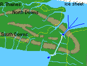
 MAP 3: 10,000 years ago, the climate had warmed up dramatically. Rivers again flow to the North Sea - sea levels slowly rise towards today's level. |
The climate warms
up Early man and animals returned to northern France, and
crossed to England over the "land bridge" - see
map 3. New forests and grasslands covered the low land,
and plentiful game attracted Stone Age hunting
groups. |
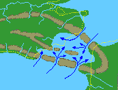 MAP 4: 8,500 years ago - sea level rises, flooding through the gaps in the hills, joining the North Sea and the Atlantic. |
Sea level
rises Eventually it broke through where deeper valleys had been
gouged out in the Ice Age -see map 4.
Swift currents flowing between the Atlantic and the North
Sea soon eroded the islands, leaving the stumps as sandbanks
in the channel. |
|
Changes
in the coastline The present-day coast is marked with yellow dots on Map 4. It shows areas like the marshes between Calais and Dunkerque, and Romney Marsh on the Kent side, where sand, shingle and mud have accumulated to make new land. |
|
|
|
|
|
Sinking
land When the ice melted, the fairly rigid land mass took time to return to its original levels - so much so, that Kent and Nord-PasdeCalais are still slowly sinking back at rate of a few cm every 100 years. This causes long-run worries for sea-flooding. Much of the low-lying coast on either side is protected by seawalls, which can be breached if there's a storm at high tide. Where the land behind is former marshland, it may be 0,5m below mean sealevel. |
|
|
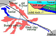
Building
the Channel Tunnel
|
|
|
Weblink:
Find out about the latest research -"How Britain was almost
joined to France", at |
|
|
Places to
visit: |
|
|
|
Related background
information |
|
|
|
|
|